 CAUP Researchers: António C. da Silva, David M. Oliveira Euclid mission: building of a reference survey, Euclid is an ESA Cosmic-Vision wide-field-space mission which is designed to explain the origin of the acceleration of Universe expansion. The mission will investigate at the same time two primary cosmological probes: Weak gravitational Lensing and Galaxy Clustering (in particular Baryon Acoustic Oscillations). The extreme precision requested on primary science objectives can only be achieved by observing a large number of galaxies distributed over the whole sky in order to probe the distribution of dark matter and galaxies at all scales. The extreme accuracy needed requires observation from space to limit all observational biases in the measurements. The definition of the Euclid survey, aiming at detecting billions of galaxies over 15 000 square degrees of the extragalactic sky, is a key parameter of the mission. It drives its scientific potential, its duration and the mass of the spacecraft. The construction of a Reference Survey derives from the high level science requirements for a Wide and a Deep survey. The definition of a main sequence of observations and the associated calibrations were indeed a major achievement of the Definition Phase. Implementation of this sequence demonstrated the feasibility of covering the requested area in less than 6 years while taking into account the overheads of space segment observing and maneuvering sequence. This reference mission will be used for sizing the spacecraft consumables needed for primary science. It will also set the framework for optimizing the time on the sky to fulfill the primary science and maximize the Euclid legacy.
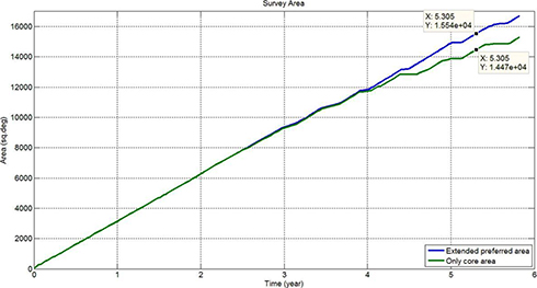
The Euclid Space Mission, recently approved by the European Space Agency, has the main goal of mapping the geometry and evolution of the dark components of the universe with an unprecedented level of accuracy. To accomplish this, Euclid will resort to Weak Gravitational Lensing and Galaxy Clustering measurements, which are expected to place close restraints in both the Dark Energy and the Dark Matter, as well as in the initial cosmological conditions. Euclid instrumentation, operating in visible and near infrared wavelengths, will allow it to determine the spectra and shape of galaxies with redshift up to z = 2, over the best 15.000 deg2 of sky. The operation of Euclid will be optimized by observing an average of 30 galaxies/arcmin2 for weak lensing measurements, while for galaxy clustering an average of 3500 galaxies/arcmin2 must be achieved. However, reaching the proposed goals for this mission, given the available resources, requires a careful selection of the most appropriate observation targets. However, in addition to the science observations, the reference survey design must also ensure that all observations needed for the calibration processes are made and that the construction of the Euclid Deep Field is also achieved with the resources available for this mission. Using end-to-end simulations, this work selected the patches of extragalactic sky which allow the fulfillment of the mission’s objectives. This was done taking into account all relevant parameters, like zodiacal background and extinction affecting the signal-to-noise ration, bright stars affecting the spectra contamination and star saturation, as well as the fixed mission parameters, including those related to the instrumentation. The Euclid Survey will initially focus on the core preferred; as the survey efficiency in this area falls, the extended preferred area will then start being used (Table 1).
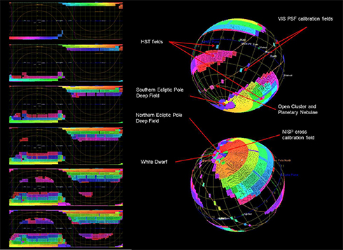
The reference sequence of observation will consist of Euclid pointing to the target area of the sky, performing an observing sequence with a total length of 4167 seconds (including three dithering operations of 75 s each) and then having a final skew of 350 seconds for reorienting Euclid to the next target. This observing sequence ensures that over 90% of the pixels in each field achieve the needed signal-to-noise ratio. This reference survey was devised using the Euclid Sky Survey Planning Tool and a schematic representation of the final result can be seen in Figure 1. The results obtained show that Euclid can, indeed, achieve the proposed goals and that they can be achieved within 5.5 years after launch, maintaining a high efficiency throughout the entire operation (Figure 2). This leaves some further 6 months of operations available for further work.
Future work around this reference survey will focus in optimizing the survey implementation so that the efficiency of this mission can be further increased. The CAUP authors have made major contributions for the mission survey definition. Specifically, they contributed to the survey implementation and algorithm definition and validation, as well as to the development of simulation tools and models. |